


| February 18 2025 |
Central Plains to Mid-Atlantic Winter Storm: (2/17 - 2/19)
By: David Hamrick, WPC Meteorologist
Meteorological Overview:
An impactful winter storm made weather headlines from the Rockies to the Mid-Atlantic region from February 17 to the morning of February 20th, 2025. A shortwave mid-level trough dropping southeast from British Columbia, Canada, crossed the central/northern Rockies on the morning of the 18th, spurring surface cyclogenesis across Texas as a 1010 mb low developed. This formed initially as a wave of low pressure on a very strong arctic cold front, with an impressive 1053 mb high analyzed at 6Z on the 19th over western North Dakota. With the shortwave making steady eastward progress across the south-central U.S., the surface low had reached a position about 100 miles south of New Orleans by 12Z on the 19th, and a secondary low of 1016 mb had formed just off the South Carolina coast by that time. These two surface lows then consolidated into a more organized single low pressure system off the Outer Banks by 6Z on the 20th with a central pressure of 1006, with the snowfall across Virginia and North Carolina beginning to move out of the region between 6Z and 12Z. Explosive cyclogenesis then occurred over the next 36 hours as the low tracked in an east-northeast direction, reaching an impressive 959 mb by 18Z on the 21st about 100-200 miles south of Cape Race, Newfoundland as a hurricane-force low as depicted by the Ocean Prediction Center. It intensified even further to 948 mb by 12Z on the 23rd before approaching the southern coast of Iceland by 00Z on the 24th as a 956 mb storm force low.
In terms of forecasting for this event, the snowfall predictions were more consistent with the model guidance across the Rockies and much of the central Plains and southern Midwest states. However, the medium range forecast models struggled more than usual with the expected snowfall across the Mid-Atlantic region. Multiple model runs in the Day 4 through 6 time period placed heavy snowfall much farther north than what actually occurred. This included signals for an impactful nor’easter type storm with 6-12+ inch totals extending across much of the Interstate 95 corridor from Washington to Boston, and even extending farther northwest to include cities such as Harrisburg and Albany. Once the event was four days away, the guidance steadily trended more suppressed with the low track and thus the axis of heaviest snow, and this was even more apparent once the short range CAM guidance became available. It turns out that the medium range guidance had more phasing with an incoming northern stream shortwave trough (in reality they ended up being more separated) and the surface high ended up being stronger than initially modeled. For the medium range period, the CMC guidance appeared to verify the best out of the global models.
Impacts:
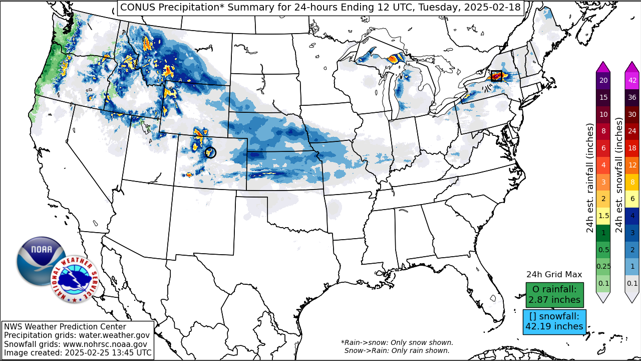
The first area of heavy snow was observed from the Rockies eastward to southern Missouri. Portions of Colorado had in excess of 18 inches, including a report of 22 inches near Mount Zirkel. Another impressive report of 28 inches was reported near Wilsall, Montana. Once the snow reached the central Plains/Midwest, snowfall totals in excess of 8 inches were reported in several areas of eastern Kansas and central/southern Missouri, and this was also a dry and powdery snow given an arctic airmass in place, leading to some blowing snow. Speaking of temperatures, overnight lows reached the -30s and even -40s from northern Nebraska to the western Dakotas and eastern Montana on the morning of the 19th, setting numerous record lows for the date.
The second area of impressive snowfall was over portions of southeast Virginia and into northeast North Carolina from the afternoon of the 19th to the morning hours of the 20th. The heaviest snowfall was reported over Southside Hampton Roads, with parts of Norfolk and Virginia Beach receiving 10-13 inches of accumulation. The same held true for locations just south of the North Carolina border. This is nearly double their annual snowfall of about 6 inches, and both 2010 and 2018 were the last times snowfall of this magnitude has been observed in that area. Lighter snow on the order of 4 to 8 inches was observed from Richmond to the Virginia Peninsula (including Williamsburg, Newport News, and Hampton). There was a sharp northern gradient to the snow, with only a dusting in the greater Washington, DC metro area. Freezing rain was also a problem farther south across east-central North Carolina where an elevated warm layer near 850 mb developed, mainly south of the Albemarle Sound and extending to the greater Jacksonville/Wilmington metro areas, with up to three-tenths of an inch of ice accretion, weighing down trees and powerlines resulting in numerous power outages. There were also reports of 1-2 inches of sleet accumulation farther inland across eastern North Carolina. Overnight lows in the 10s and low 20s made things difficult for those without power following the winter storm.
Schools across the affected areas of the Mid-Atlantic region were closed from Wednesday to Friday of that week, and there were even some 2-hour delays to the school day on the following Monday, February 24th, across portions of northeast North Carolina. Road travel was severely affected by the winter storm across the region, with Virginia State Police reporting at least 500 separate automobile crashes across the state. Hundreds of flights were cancelled, with Charlotte, NC alone reporting 225 cancelled flights. Amtrak also cancelled multiple passenger trains south of Washington, DC on the 20th as railroad crews had to remove heavy snow off the tracks.