Excessive Rainfall Discussion
NWS Weather Prediction Center College Park MD
858 PM EDT Fri Jun 12 2026
Day 1
Valid 01Z Sat Jun 13 2026 - 12Z Sat Jun 13 2026
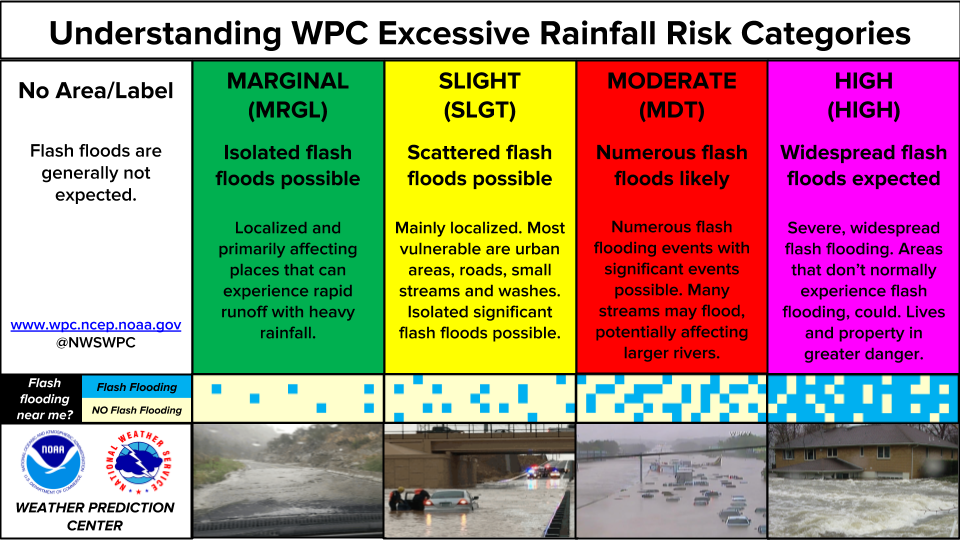
...THERE IS A SLIGHT RISK OF EXCESSIVE RAINFALL ACROSS PORTIONS OF
EASTERN KANSAS, SOUTHWEST MISSOURI, AND NORTHERN NEW ENGLAND...
...Northern New England...
Decreasing intensity and decreasing areal coverage on radar imagery
combined with warming cloud top temperatures shown on satellite
imagery point to a rapidly diminishing excessive rainfall threat.
The Slight and Marginal areas were removed from the Northeast.
Mid-Atlantic Region.
The downward trend in rainfall intensity noted in New England was
also occurring in the Mid-Atlantic region...but the convection was
still strong enough to support localized rainfall rates in excess
of an inch per hour. The threat is expected to diminish
quickly...perhaps as early as 03Z or 04Z...given the loss of
daytime heating. However it was too early to remove the Marginal
in this part of the country.
Eastern Kansas into Southwest Missouri...
Maintained the Slight Risk area from parts of Kansas into
southwestern Missouri in deference to latest CAMs showing upscale
growth of convection later tonight as storms initially over parts
of Colorado and New Mexico move eastward and encounter greater
instability and forcing. The 00Z sounding at DDC showed 30 kt
southerly flow above 850 mb that was drawing higher dewpoints into
the region. The latest mesoscale guidance has a good signal for
heavy rainfall...with the expectation that hourly rainfall rates
reach 2.5 inches per hour with total amounts to 4 hours that
results in isolated to widely scattered flash flooding. There
latest CAMs introduce some doubt about the northern extent of
rainfall in Kansas and Missouri...but daytime runs of the HREF and
REFS consistent in the rainfall footprint expansion given the low
level jet and the evolving shear pattern. See Mesoscale
Precipitation Discussion 0400 for latest details.
Bann
Day 1 threat area:
www.wpc.ncep.noaa.gov/qpf/94epoints.txt
Excessive Rainfall Discussion
NWS Weather Prediction Center College Park MD
858 PM EDT Fri Jun 12 2026
Day 2
Valid 12Z Sat Jun 13 2026 - 12Z Sun Jun 14 2026
...THERE IS A MODERATE RISK OF EXCESSIVE RAINFALL FOR PORTIONS OF
EASTERN KANSAS AND SOUTHWEST MISSOURI...
...Central Plains to Mid-Mississippi Valley...
20Z Update: In coordination with the local WFO's across eastern
Kansas into Missouri, a Moderate Risk was issued for the D2 period
with emphasis across eastern Kansas into southwestern Missouri.
Deep moist environment will preclude the arrival of a prominent
shortwave ejecting into the Central Plains, making headway into the
mid-Mississippi Valley on Saturday afternoon and evening.
Instability gradient will be present across northern MO into Iowa
as a cold front begins to slowly press south with the guide of a
potent shortwave trough dropping out of Canada. This is the making
of an increasingly convergent low to mid-level setup within a very
favorable environment across the nation's mid-section.
Instability across eastern KS into MO will be quite robust with
model forecast MUCAPE along and east of I-35 into the 3500-5000
J/kg range by the time we reach peak diurnal heating. Coupled with
a deep moisture pool in the column, any convective development will
comprise of significant rainfall rates as noted via elevated hourly
and 3-hourly prob fields within the latest 12z HREF. Deterministic
output from various CAMs indicate rates between 2-3"/hr with likely
higher intra-hour rates exceeding 4" at times, especially as you
get further south into southeastern KS and southern MO where
instability will be maximized. QPF forecasts are consistent for
2-4" totals across the area south of Topeka down into the
Joplin/Springfield region of southwestern MO. Kansas City at this
time on the edge of the potential with a split in guidance on where
the heaviest precip will reside for the northern and northeast
periphery of any established maxima. Considering such a close
proximity to the max, and the D2 error in convective forecasting
still a concern, there's potential that the urban center can get
into some of the heavy precip as it materializes on Saturday
evening. With a Flood Watch issued over the metro and surrounds,
decided to include the city in the MDT risk to maintain consistent
messaging and signaling a heightened threat compared to normal.
A high-end SLGT is forecast for much of the remainder of Missouri
not encompassed within the MDT risk. There could very well be an
initial round of thunderstorms in the morning across southern MO in
conjunction to the shortwave moving across the area as referenced
in the D1 update. Any rainfall occurring would be a priming
scenario for what would transpire later as the cold front to the
north begins pushing south with a strong low-level convergence
pattern taking shape over the mid-Mississippi Valley. The area of
greatest concern, outside the MDT risk, is likely across
northeastern MO where recent rainfall over the past 72hrs have led
to significant flash flooding over portions of the area allowing
for highly compromised soils and swollen streams and creek beds
located in the area. Local FFG's in the 1/3/6 hour thresholds
continue to run much lower than normal with most of the thresholds
between 1-2" for either temporal range meaning any heavy convection
will be susceptible to flash flood prospects. As of now, the saving
grace for areas north of I-70 will be a majority of the precip will
be due to the frontal progression and any convection should be more
progressive in the grand scheme. This typically negates significant
flooding prospects as rainfall will only last for so long before it
moves away and we see a de-escalation of hydrologic impacts. In any
case, the threat is still elevated across much of the mid-
Mississippi Valley, so the period will bear watching for any short
term upgrade potential if trends allow.
...Midwest...
20Z Update: A strong cold front will migrate through the region
allowing for convective initiation over the Central Midwest into
the western Great Lakes, overlapping areas that have been hit
recently with periods of heavy rainfall. The highest potential is
across southern and eastern IA into northern IL where significant
rains have impacted area FFG's considerably over the past 72hrs
meaning chances for flash flooding are easier to attain.
Progressive nature of precip is the reason this area is just
outside the more significant rainfall prospects, however
environmental conditions are still favorable over the area with
deep moisture pooled as far north as I-80 for the setup. As the
front moves out of the area, drier air will advect into the region
in its wake ending the threat for the rest of the forecast period.
Widespread 1-3" with local to 4" is forecast in this area of the
CONUS, certainly enough to cause scattered flash flood threats as
the pattern evolves when you couple with the lower FFG's in place.
A broad SLGT risk is forecast for the potential.
Kleebauer
Day 2 threat area:
www.wpc.ncep.noaa.gov/qpf/98epoints.txt
Excessive Rainfall Discussion
NWS Weather Prediction Center College Park MD
858 PM EDT Fri Jun 12 2026
Day 3
Valid 12Z Sun Jun 14 2026 - 12Z Mon Jun 15 2026
...THERE IS A SLIGHT RISK OF EXCESSIVE RAINFALL FOR PORTIONS OF
TEXAS AND THE LOWER MISSISSIPPI VALLEY...
20Z Update: Little changes were necessary for the D3 period as
guidance remained fairly consistent on the premise of heavy
rainfall across the Southern Plains to Lower Mississippi Valley on
Sunday. The SLGT risk across west TX was pushed further west into
southeastern NM to reflect the latest QPF increase from 12z
guidance. Overall synoptic pattern remains favorable heavy rain
across much of the area south of I-40 with the heaviest rain likely
to occur over the Lower Mississippi Valley given the approach of
the cold front to the north and a very moisture rich environment
thanks to advection of Gulf air. Will be monitoring closely for any
targeted upgrades, but will likely have to see how the previous
period's convection evolves before doing so.
Kleebauer
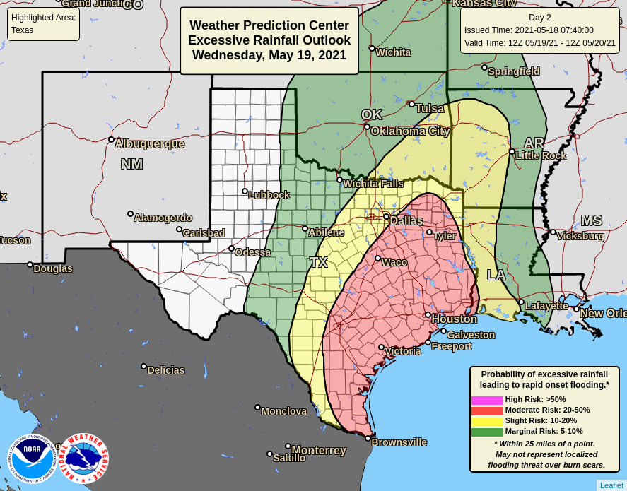
...Southern Rockies, Texas to Southeast...
A cold front pushes down the Southern Plains into Texas on Sunday.
This shunts the heavy rain focus south of Saturday and provides a
strong focus for convective development in a rich Gulf-sourced
moisture environment. PW anomalies are 2 to 3 sigma above normal
across Texas (south of the Panhandle) by that afternoon with 2
sigma anomalies expanding east to Alabama by late Sunday night.
Expansion of the Slight Risk to both North Texas and the Houston
metro areas are warranted given the environment as well as the 00Z
consensus of the UKMET and EC-AIFS for the Houston area, and the
RRFS and RDPS for North Texas. Furthermore, a decent signal for
lasting thunderstorm development is over West Texas in the Permian
Basin into the Concho Valley, so a Slight Risk was raised there as
well.
Additional terrain driven diurnal activity is expected over the
Southern Rockies/Sacramento and Davis Mtns. This activity should
spread southeast through the evening, so the Marginal Risk was
expanded over the southern High Plains.
A surge of moisture up the southern Appalachians Sunday morning
brings enough of a heavy rain threat for a Marginal Risk expansion
up to the westernmost section of Virgina.
...Hampton Roads and Delmarva...
Southwesterly low level flow from the Carolinas bring 2" PW to the
Mid- Atlantic coast Sunday afternoon ahead of a cold frontal
passage that night. Evening thunderstorms should be heavy and slow
enough to warrant a Marginal Risk.
Jackson
Day 3 threat area:
www.wpc.ncep.noaa.gov/qpf/99epoints.txt
Excessive Rainfall Discussion
NWS Weather Prediction Center College Park MD
858 PM EDT Fri Jun 12 2026
Day 4 and Day 5
Valid 12Z Mon Jun 15 2026 - 12Z Wed Jun 17 2026
...A SLIGHT RISK OF EXCESSIVE RAINFALL EXISTS FOR PORTIONS OF THE
SOUTHERN PLAINS, LOWER MISSISSIPPI VALLEY, AND THE SOUTHEAST...
20Z Update...
The suite of 12Z guidance has largely remained consistent with the
large scale flow pattern and the higher chances of heavy to
excessive rainfall being confined in proximity to the gulf coast.
There was little need to make more than subtle nudges to the
Marginal Risk areas in the previously-issued outlook...and no
changes were made to the Slight risk areas on either day,
Bann
Previous Excessive Rainfall Discussion
Overall, not much change from the previous forecast, with the
overnight guidance continuing to present a good signal for highly-
efficient training storms along a slow-moving front settling into
the region.
Models continue to show a cold front settling slowly south though
the southern Plains, lower Mississippi Valley, and the Southeast as
shortwave energy gradually amplifies a broad upper trough centered
along the Mississippi Valley on Monday. A deepening pool of
moisture along the front, fed by southerly low level inflow from
the western Gulf, will fuel the potential for highly-efficient
showers and storms. Guidance continues to show PWs increasing to
2.25 inches (2.5 to 3 std dev above normal) along and ahead the
front from south South Texas to southern Alabama on Monday.
Interacting with this moisture is expected to be an area of
enhanced ascent provided by right-entrance region upper jet forcing
positioned along the base of the amplifying trough. In addition to
the deep moisture and large-scale ascent, repeating storms are
expected to raise the potential for heavy amounts and flash
flooding concerns. A Slight Risk was maintained from southeastern
Texas to central and southern Alabama on Day 4.
By Tuesday, the upper trough axis begins to shift to the east,
pushing the front, deeper moisture, and the better chance for heavy
rain farther south and east along the Gulf Coast. For Day 5, a
Slight Risk was drawn from southeastern Louisiana to southwestern
Georgia.
While Slight Risks were drawn for both periods, given the potential
for several inches of rain in some locations, an upgrade to a
Moderate Risk may be required in future updates if the signal
persists as the event draws nearer.
Pereira


