Excessive Rainfall Discussion
NWS Weather Prediction Center College Park MD
905 PM EDT Mon Jul 13 2026
Day 1
Valid 01Z Tue Jul 14 2026 - 12Z Tue Jul 14 2026
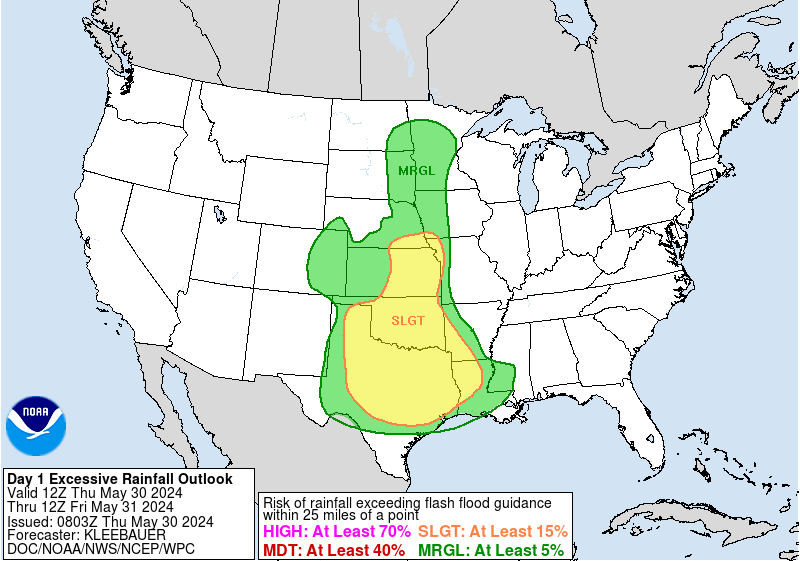
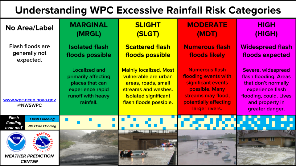
...THERE IS A MODERATE RISK OF EXCESSIVE RAINFALL OVER SOUTH-
CENTRAL TEXAS...
...01Z Update...
With regards to the Moderate, the forecast remains much the same.
Recent runs of the HRRR, as well as the latest HREF/REFS continue
to present a strong signal for heavy rain developing overnight over
portions of south-central Texas, including the southern Hill
Country and the San Antonio metro. HREF/REFS continue to show high
neighborhood probabilities (greater than 70 percent) for overnight
accumulations exceeding 3 inches, with some greater than 50
percent probabilities for exceeding 5 inches within the Moderate
Risk area. Both ensemble suites also indicate amounts are likely to
exceed 3-hr FFGs during the early-morning hours.
Elsewhere, made some adjustments based on the previously noted
guidance, as well as recent radar/satellite trends. Much of the
Slight Risk starting west of the Moderate Risk area and extending
east to the Carolinas was maintained. However, did trim away some
of the northern extent as well as some portions of the lower
Mississippi Valley and central Gulf Coast where drier, more stable
air is expected to limit the potential for widespread heavy rain
and flash flooding concerns.
Pereira
...16Z Update...
...Texas...
The incoming 12Z guidance continues to paint a bleak picture for
flooding potential across a portion of south-central Texas,
generally in the area from San Antonio west to the Rio Grande
River. A strong low level jet transporting plentiful deep tropical
moisture northward up the Rio Grande Valley into South Central
Texas. As that moisture hits the southern edge of the Edwards
Plateau, uplift from the Plateau combined with some instability
around 1,000 J/kg, and weak flow aloft will support training and
backbuilding thunderstorms developing in this area from the late
evening and through the rest of the overnight.
Earlier rainfall in this area over the past 24 hours or so on the
order of a half-inch to 2 inches in spots has already saturated the
soils, especially along the Rio Grande near Del Rio. The
expectation of multiple inch per hour rainfall rates with the
strongest storms are likely to result in flash flooding,
especially the rivers draining the southern Edwards Plateau.
Much of the greatest flooding impacts are expected with the ongoing
heavy rain that continues into the Day 2 period in this region, but
the increased heavy rainfall forecast in these area prior to the
12Z end of the Day 1 period and favorable hydrology both were
contributing factors to the Moderate Risk upgrade.
Elsewhere, the risk levels were left largely unchanged, both in the
Southwest with the developing monsoon as well as across much of the
Southeast, where widespread but widely scattered clusters of storms
are likely to produce localized flash flooding, but with low
confidence on where those storms will form and how much rain they
will produce.
Wegman
...Texas into Louisiana...
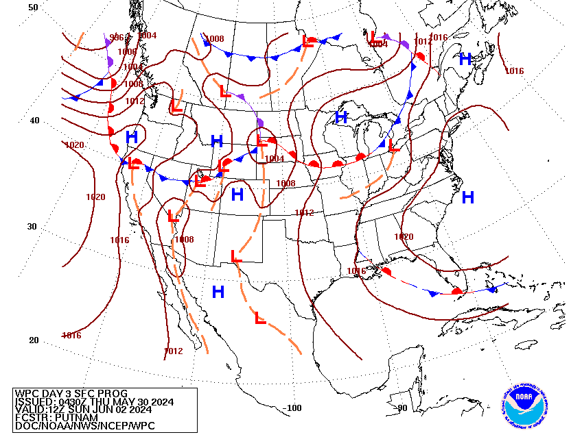
Front analyzed over OK/AR will slip southward as we move into
Monday with an increasing axis of low-level convergence along and
ahead of the boundary. Environment across the Southern Plains into
the Lower Mississippi Valley can be best described as oppressive as
deep layer moisture from Gulf origin has made its presence known
over much of the South with much of TX into Louisiana as no
exception. Upper pattern across the CONUS will be liable to cause
some headaches over much of the southern tier of the U.S. as broad
upper ridging focused over the Northern Plains will lead to more
east to west migrations of disturbances rounding the base of the
ridge and entering these suitable convectively allowing
environments.
The 00z HREF continued a trend of widespread convective coverage
anticipated in the D1 time frame with multiple areas of interest
spanning from the Carolinas over into the Southern Plains. The
primary targets for enhanced rainfall are currently positioned
within the Lower Mississippi Valley extending west through Central
TX, eventually with the western fringes located in the terrain of
southwest TX. Prob fields have become very bullish on the prospects
of locally heavy rainfall in several areas spanning west TX into LA
with the greatest neighborhood probs for >3" (50-80%) and >5"
(40-70%) located over east TX into the Sabine with an extension
along the I-10 corridor between Lake Charles to Lafayette. This
trend has been noted in successive HREF outputs with the ensemble
mean QPF now upwards of 2-3" over a large area east of I-35. Make
no mistake, however, the threat for excessive rainfall totals over
3" does not stop in these areas as multiple CAMs deterministic
signatures indicate a potential for significant rainfall in-of the
I-35 corridor extending west into Hill Country and the Edwards
Plateau the back half of the period. This setup would transpire
later in the evening with the additional support stemming from an
approaching mid-level shortwave migrating southwest under the guide
from the general 500mb pattern across the Central and Southern
CONUS. Weak LLJ will likely develop after 00z Tue across the RGV
and South TX with that evolution likely providing a bit more
enhancement in the boundary layer convergence scheme. Timing of any
energy and overall positioning of the front will be a major
dictator of what could transpire in the back half of the forecast,
so currently went with a high-end SLGT to cover the primary
concerns from southwest TX through central and southwestern LA with
a broad SLGT extending further east through the rest of the
Southeast and Southern Mid Atlantic (More of this area below).
This is a setup that could spell surprises considering a very
favorable environment in place that will likely assert some very
prolific rainfall rates at times as deterministic samples from CAMs
already indicating the possibility of >3"/hr rainfall prospects
across a good portion of TX into LA.
...Southern Mid Atlantic into the Southeast U.S...
Current UA and WV satellite analysis indicates a weak closed-low
located over central TN and a slow-moving quasi- stationary front
at the surface positioned over the Carolinas through the southern
Tennessee Valley into the Southern Plains. Sprawling upper ridge
centered over the Northern U.S. is really driving this anomalous
pattern with surface ridging extending from the Ohio Valley and
Northeast down towards the area of the front. The entire setup
provides a strong low to mid-level convergence pattern that is
driving quite an axis of heavy convection over the Carolinas this
evening with a ton of convection occurring earlier Sunday over much
of the Southeast.
Generally persistent 500mb setup will allow for a repeat of
widespread convection during the daytime hours, Monday, with
perhaps a small shift in the northern periphery of the coverage
further south compared to Sunday as high pressure filters in over
much of VA/WV and the Central Mid Atlantic. HREF blended mean QPF
remains bullish with widespread 1-2" totals located across western
and southern NC down through SC where the areal maxima is
positioned squarely along the eastern fringes of the Piedmont into
Low Country. A strong neighborhood and EAS signature exists within
the latest 00z HREF for >5" and >2", respectively, a textbook
indicator of at least scattered flash flood prospects over the area
in question. The most prominent signatures reside in SC with more
modest interpretations in the prob fields located over the
Southeast towards the northern half of GA/AL into MS. Despite
widely scattered coverage this past afternoon, several flash flood
warnings were necessitated thanks to a very efficient warm rain
process for much of the Southern U.S. as deep layer moisture and
very high regional theta_E's offered deep warm cloud layers noted
via widespread WBZ heights >14k ft when assessing both
observational RAOB's and forecast soundings from various CAMs.
In any case, this is a textbook, widespread SLGT risk prospect
considering the variables above and a general persistence in the
pattern. A SLGT risk now extends through much of the Southern
Appalachians, southern NC, and points south with the inclusion of
the western FL Panhandle and Central Gulf coast areas.
...Southwest U.S. into the Sierra's...
As the upper pattern remains persistent for areas further east, the
Southwest U.S. will lie within the western flank of the ridge
allowing for prevailing southerly flow aloft to advect deeper
moisture north and northwest allowing for greater convective
potential over a larger area as we move into Monday. Instability
fields are primarily weak for areas within the Great Basin and
interior CA, but are much more favorable for locations within the
Desert SW of AZ into the Mogollon Rim region. The combination of
increasing moisture (+2 standard deviation PWATs) and increasing
thermodynamic influences noted via improved MUCAPE fields will lead
to scattered heavy rain prospects across the more susceptible flash
flood areas located from the Sierra's down through the Desert
Southwest of CA/AZ for Monday. A MRGL risk is in place for the
period at these locations with the best threat likely over
southeastern AZ into the Mogollon Rim according to the latest HREF
prob fields for 1 and 3-hr FFG exceedance forecast.
Kleebauer
Day 1 threat area:
www.wpc.ncep.noaa.gov/qpf/94epoints.txt
Excessive Rainfall Discussion
NWS Weather Prediction Center College Park MD
905 PM EDT Mon Jul 13 2026
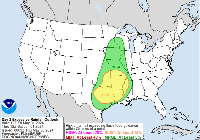
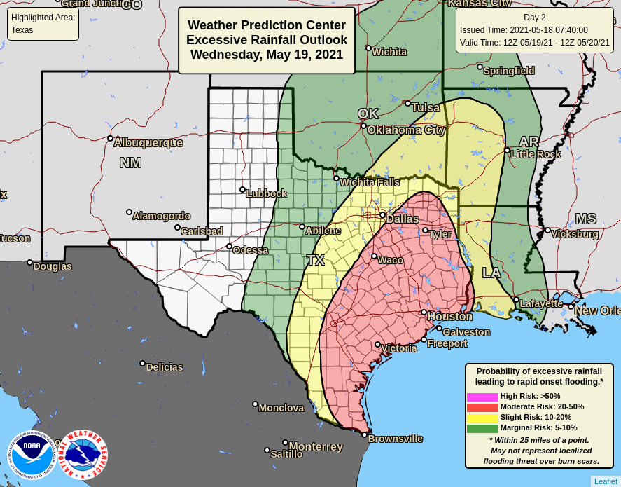
Day 2
Valid 12Z Tue Jul 14 2026 - 12Z Wed Jul 15 2026
...THERE IS A MODERATE RISK OF EXCESSIVE RAINFALL ACROSS PORTIONS
OF THE EDWARDS PLATEAU, CENTRAL RIO GRANDE VALLEY, AND HILL COUNTRY...
...2030Z Update...
...Texas...
With CAMs guidance, confidence continues to increase in a multi-
night significant flash flooding event across a portion of south-
central Texas. Essentially, an upper level low over northern Mexico
will help funnel abundant Gulf moisture northward into the Edwards
Plateau both continuing into Tuesday morning from Monday night's
event, and then a renewal of storms causing flash flooding again
Tuesday night into Wednesday. A second mid-level disturbance,
currently over northeastern Texas, will drift southwestward through
the day and merge with the ongoing disturbance over far northern
Mexico just east of the Big Bend. This should help renew the
forcing for thunderstorms again for more storms Tuesday night.
There is reasonably good confidence that if storms form, it will be
over the same areas Tuesday night as will be hit tonight. So the
question becomes how widespread and strong those storms will be,
and on that note there are different camps in the guidance, with
some showing another very active night of heavy flash flooding
rains, and others showing far less-so, with the main action being
tonight into Tuesday morning. How this resolves with future
forecast updates will ultimately be the deciding factor as to
whether or not a High risk upgrade is needed, likely targeting the
area between San Antonio and the Rio Grande River along the
Balcones Escarpment.
Regardless of what happens with the heavy rains on Tuesday night,
tonight's event looks to be in the cards with high confidence on
multiple inches of rain, which will continue into Tuesday morning.
Hydrologically, the area is extremely flash-flood prone, given
enough heavy rainfall, likely one of the most prone areas of the
country. Thus, almost regardless of what happens again Tuesday
night, tonight's event will be significant for the area. Thus, in
addition to the Day 1 Moderate, the Day 2 Moderate area is for the
likely ongoing flash flooding impacts expected in this region
through Tuesday morning. In collaboration with the EWX/New
Braunfels, TX forecast office, a higher-end Moderate is in effect
for the area from U.S. 57 north almost to I-10, all west of the San
Antonio Metro.
...Mississippi and Alabama...
A Slight Risk upgrade was introduced with this update for portions
of central Mississippi and Alabama. In a similar fashion as further
west in Texas, a mid-level low will be moving over a very
moisture-rich environment across the South. However, unlike further
west in Texas, no topography and most of the storms occurring at
peak heating from late morning through early evening make this
event a bit different than further west. The disturbance will
provide enough forcing, given ample instability, to produce
widespread shower and thunderstorm activity across Mississippi and
Alabama. The disturbance will act as a focus, allowing the
activity to organize, which in turn increases the potential that
cold pools and other local forcings will allow for training and
backbuilding of convection. In addition to storms impacting the
area now, recent heavy rains from past days have also saturated the
soils in this area, which have in turn lowered FFG thresholds
across the Slight Risk area. With more widespread convection
expected Tuesday afternoon, widely scattered instances of flash
flooding are expected.
Wegman
...Previous Discussion...
...Texas...
A significant, multi-day threat for heavy rainfall will begin on
Tuesday across portions of west TX with the threat looming largest
over the areas along and west of the Rio Grande near and south of
I-10. There has been a growing consensus over the last several days
of significant rainfall potential brewing across the Edwards
Plateau and surrounding areas with the setup a textbook case of
primed low- level convergence thanks to frontal positioning and the
threat of an approaching MCV complex migrating westward from
Central TX. Latest CAMs are finally in range of the threat, at
least the initial setup leading into what will be a very active
Tuesday night and Wednesday morning across areas west of I-35 along
and south of I-10 into Hill Country. Disturbance moving into the
region will only act as a provider for sufficient low-level
convergence in an already buoyant environment situated over much of
the southern half of TX. LLJ enhancement over the RGV will only
act as a beneficial product for low-level moisture transport and
convergence which will allow for a focused axis of heavy rainfall
to materialize and slowly drift over the same areas for several
hours once the activity initiates. ML guidance and global ensembles
have been extremely consistent in their interpretations of what
will transpire with little wavering in the axis of heaviest QPF and
only providing greater magnitudes as we move closer in time.
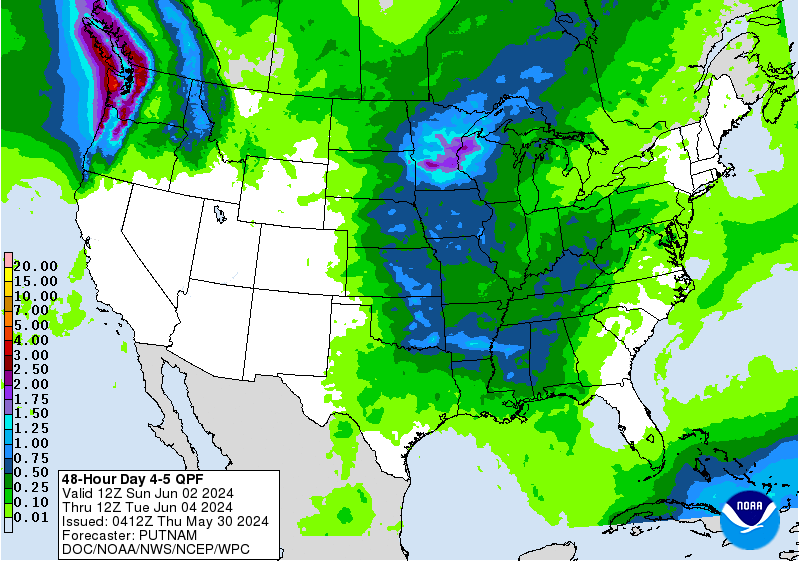
Mean QPF for the D2 time frame is now upwards of 3-4", locally
higher across much of the Edwards Plateau with the focus over Del
Rio and points east into Hill Country. Bias corrected ensemble is
also indicating some 4-5" totals as of the latest iteration, a
signature generally seen for events of upper echelon potential.
Considering the favorable environment and likely efficient rainfall
given PWATs between 2-2.2" forecast, prospects for >2"/hr rainfall
are not only certain, but there's a threat for even some 3-4"/hr
rates in the strongest cell cores that could push totals for the
first day of the event to >5", as noted via modest probs within the
NBM over the area. In coordination with the local SJT and EWX
offices, a MDT risk was added across the aforementioned areas with
emphasis on the Edwards Plateau where the most consistent signals
for >3" rainfall exist among all ensembles.
Across central and southwest TX, locally heavy rainfall prospects
will only continue, with the latter the most likely to see some
type of overlap in the general convective coverage as thunderstorms
focus over the regional topography from the Davis Mtns. into the
Stockton Plateau. Central TX is a toss-up currently with the
greatest threat likely to be in proximity to the quasi-stationary
front and any lingering outflows that materialize from
convection the previous period. Models are generally aggressive
in-of San Antonio and the I-10 corridor for the first half of the
forecast, so it will be interesting to see the trends as we step
forward in time. For now, a broad high-end SLGT is forecast over
the above areas, but there is potential for an upgrade in either
area, pending trends in hi-res guidance and observational trends as
convection occurs from the end of D1 into D2.
...Southwest U.S. into the Great Basin...
Continued impacts from lying into the western flank of the ridge
centered over the Northern U.S. as prevailing southerly flow will
just maintain a prevalent moisture advection regime poleward over
the Desert Southwest into the Great Basin. Models remain consistent
in their interpretations of locally heavy rainfall over both
regions with the heaviest QPF centered over AZ, but potentially
greater impacts in those more flash flood prone areas located in
the interior west, including those slot canyons over UT/NV.
Rainfall rates will be the driving factor for flash flooding in
this scenario with instability generally favorable (>750 J/kg
MUCAPE) over a large portion of the Western CONUS. The combination
of PWAT anomalies >2 deviations above normal and elevated
instability favors at least widely scattered flash flood potential,
which this setup is leaning into the textbook signature as
forecast. The previous MRGL risk was maintained with some expansion
further north around the area of the Sierra's.
...Northern Rockies...
PWATs encroaching the 90-99th percentile over the western half of
MT coupled with favorable instability and approaching mid-level
troughing to the west will allow for scattered to perhaps
widespread convection to materialize over the Northern Rockies
Tuesday afternoon and evening. Totals are currently relatively
meager in an areal average sense, however some of the deterministic
are producing some local 1-2" amounts with impacts realistically
only a few hours, at best when convection occurs. These types of
rates are historically favorable for flash flood prospects across
the Northern Rockies, so the previous MRGL risk was maintained
over the area as the signal remains consistent.
...Northern Vermont and New Hampshire...
A strong closed low over Northern Quebec will pinwheel southeast,
well north of the Canadian border in New England, but will aid in a
broad brush of robust mid-level vorticity over the northern tier of
both VT/NH during peak diurnal heating. MUCAPE between 2500-3500
J/kg will be located across the northern tier of both states
leading to a targeted area for locally heavy rainfall with rates
likely to approach close to 2"/hr as noted in the latest HREF prob
fields. A quick 1-3" is forecast across this small area of New
England, however this area is notorious for local terrain
influences that could cause issues with any appreciable rainfall in
that short period of time. A MRGL risk was added for the threat in
the above area.
Kleebauer
Day 2 threat area:
www.wpc.ncep.noaa.gov/qpf/98epoints.txt
Excessive Rainfall Discussion
NWS Weather Prediction Center College Park MD
905 PM EDT Mon Jul 13 2026
Day 3
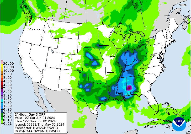
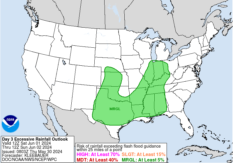
Valid 12Z Wed Jul 15 2026 - 12Z Thu Jul 16 2026
...THERE IS A MODERATE RISK OF EXCESSIVE RAINFALL ACROSS PORTIONS
OF THE LOWER TRANS PECOS, EDWARDS PLATEAU, RIO GRANDE VALLEY, AND
HILL COUNTRY...
...2030Z Update...
...Texas...
The Moderate Risk area has been expanded this afternoon in
coordination with EWX/New Braunfels, TX, SJT/San Angelo, TX, and
MAF/Midland-Odessa, TX forecast offices.
As mentioned in the D2 discussion, while there remains some
disagreement in the guidance as to how heavy ongoing rainfall into
Wednesday morning will be across the region, it remains likely that
there will be heavy rainfall to some degree along the Edwards
Plateau region on Wednesday morning, with another round likely to
impact portions of the area again Wednesday night into Thursday.
Given the expected heavy rainfall on both days 1 and 2, should the
forecast remain similar in the coming days as this period moves
into the CAMs guidance range, it appears probable a High Risk
upgrade will be needed. By Day 3, as usual, uncertainty increases
both with the magnitude of the expected heavy rainfall, especially
into Wednesday night, as well as the location. Some good news is
that for now the guidance appears to suggest the heaviest rainfall
by Wednesday night will be shifting westward up the Rio Grande,
impacting generally from Del Rio westward. Meanwhile the heaviest
rains expected tonight and again Tuesday night are expected to
focus mostly east of Del Rio along the Balcones Escarpment. This
shifting of the heaviest rains will be huge for avoiding High Risk
level impacts, though despite the heavy rains expected to impact
some portion of that area Wednesday night, the area east of Del Rio
will not be entirely rain-free, just in all probability
experiencing lighter rains as the focus shifts west. That said,
guidance usually shifts south and east with time, especially once
it gets into the CAMs range, so there still is plenty of concern
that Wednesday night's rainfall event will also focus in the same
region.
A higher-end Moderate Risk area was introduced with this update
from west of San Antonio (mostly due to impacts from Wednesday
morning) almost to the eastern edge of Big Bend National Park,
including Del Rio. The surrounding Moderate Risk also includes
metro San Antonio. At the moment this threat is a combination of
urbanization, some heavy rainfall impacting the metro at times on
both Days 1 and 2, and finally, afternoon convection that likely
marks the start of the heavy rainfall event into the overnight
period Wednesday night as the storms move west with time.
...Mogollon Rim region of central Arizona...
In coordination with the FGZ/Flagstaff, AZ; PSR/Phoenix, AZ; and
TWC/Tucson, AZ forecast offices, a Slight Risk area from the
Mogollon Rim south was introduced with this update. While monsoonal
rains will impact this area on both later this afternoon and again
Tuesday afternoon, the moisture and forcing will both increase
further by Wednesday afternoon. Any storms will form along the
Mogollon Rim itself, with some probability due to topography, cold
pools, or other local forcings, that the storms will backbuild
south off the topography. For now it appears this activity will not
impact metro Phoenix with widely scattered flash flooding, but the
area just to the north in the foothills leading to the Mogollon Rim
are the areas most likely to see impacts.
Wegman
...Previous Discussion...
...Texas...
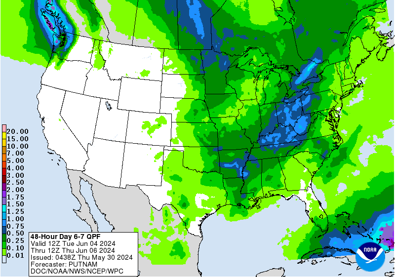
Setup from the D2 will linger into D3 a our mid-level disturbance
is likely to meander for at least one more period leading to low-
level convergence pattern continuing across the same areas impacted
in the D2. Models are consistent in the signature for an additional
round of heavy rainfall centered over the Edwards Plateau with a
bit more of a northern extension into the Lower Trans Pecos and
lower Concho Valley. Considering the overlap from the previous
period, multi-day totals are upwards of 6-8" currently with areas
of 10+ inches plausible when you consider the low-bias in some of
the global deterministic outputs when it comes to convection. The
setup is one that signals significant flash flood concerns given
the multi-day impact and the forecasted totals in place. A MDT risk
was introduced for the above areas to account for the impacts on
back-to-back days, as well as the agreement in ensembles and ML
outputs that can be traced back to the last 3-4 days exhibiting a
consistent result. This period will need to monitored for further
upgrades as we move forward in time as a lot will stem from what
happens the prior periods.
...Western U.S...
Broad upper ridge centered over the Northern U.S. will continue to
provide significant moisture advection into the interior west
leading to scattered convective signals from the Canadian border
down into the Desert Southwest with flash flood concerns in those
more susceptible areas out west. This setup is is a continuation
from the previous period, but the expansion of heavy rainfall is
further east comparatively as the ridge nudges eastward and shifts
the general pattern in tandem. Broad MRGL risk exists for the
period across the West.
Kleebauer
Day 3 threat area:
www.wpc.ncep.noaa.gov/qpf/99epoints.txt
Excessive Rainfall Discussion
NWS Weather Prediction Center College Park MD
905 PM EDT Mon Jul 13 2026
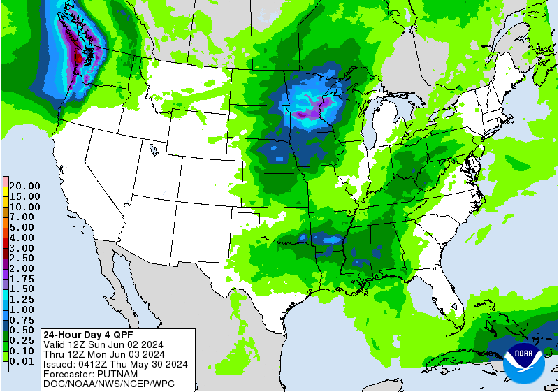
Day 4 and Day 5
...THERE IS A SLIGHT RISK OF EXCESSIVE RAINFALL ACROSS PORTIONS OF
CENTRAL AND WEST TEXAS ON THURSDAY INTO THURSDAY NIGHT...
2030Z Update...
Daytime guidance did not present any reason to make significant
changes, therefore only minor adjustments were made to the outlook
areas, including the higher-end Slight Risk on Day 4 from the
Edwards Plateau into portions of the Concho Valley and Hill
Country.
Pereira
...Texas...
A Slight risk is maintained over portions of central and west TX
for Thursday (day 4), marking a continuation of a potentially
significant multi-day flash flood event. The environmental setup
remains favorable for organized cell training and backbuilding.
Notably, an increase in low level wind fields should yield even
stronger 850mb southerly moisture transport than seen on
preceding days. However, given this will be day 4 of the event,
inherent mesoscale uncertainties exist regarding the exact
positioning of the remnant MCVs and the spatial alignment of the
instability field. Furthermore, the broader environmental moisture
field is forecast to become somewhat less robust, with a smaller
areal coverage of 2" PW values. With that said, antecedent soil
conditions could be highly saturated over portions of the region
by this time, heightening hydrologic sensitivity. This is
considered a higher end Slight risk from the Edwards Plateau into
portions of the Concho Valley and Hill Country. The potential is
certainly there that the MDT risk currently valid for days 2 and 3
may need to be extended into day 4 (Thursday) as well.
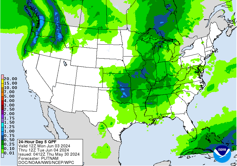
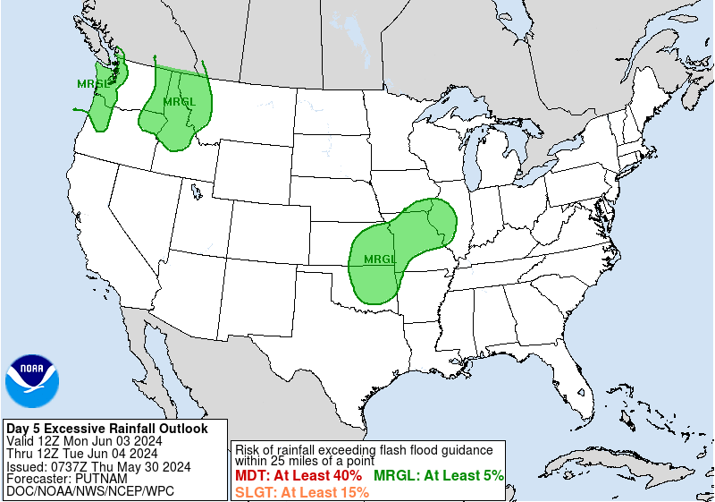
By day 5 (Friday), the model signal becomes a bit less pronounced
for this multi-day heavy rainfall event. Convective evolution is
less certain by this time, and global deterministic and ensemble
QPF signals become more muted. Thus we will keep the risk at a
Marginal level, although certainly a chance the multi-day event
continues into Friday, with Slight risk upgrades a possibility as
we get closer.
...Western U.S...
A broad active monsoonal pattern will continue across much of the
western U.S. Thursday into Friday. An anomalous PW axis stretching
from AZ northward into MT is forecast to remain above the
climatological 90th percentile, and locally higher in some spots.
This airmass will sustain a localized flash flood threat across an
expansive corridor spanning from portions of eastern CA, AZ, and
NM northward to MT.
The highest absolute moisture and instability values during the
period are forecast from portions of southeast CA into AZ. Model
guidance indicates some uptick in instability as well, with peak
CAPE values currently expected on Friday. Similarly, deterministic
and ensemble QPF footprints gradually ramp up through the period,
peaking across AZ on Friday. While a broad Marginal risk currently
covers the multi-day isolated flash flood risk, embedded Slight
risk upgrades may eventually be required. Friday currently presents
the stronger signature for a more concentrated flash flood threat,
particularly over southeast CA, AZ and southern UT, and trends
will be monitored closely.
Chenard
Excessive Rainfall Discussion
NWS Weather Prediction Center College Park MD
905 PM EDT Mon Jul 13 2026
Day 4 and Day 5
...THERE IS A SLIGHT RISK OF EXCESSIVE RAINFALL ACROSS PORTIONS OF
CENTRAL AND WEST TEXAS ON THURSDAY INTO THURSDAY NIGHT...
2030Z Update...
Daytime guidance did not present any reason to make significant
changes, therefore only minor adjustments were made to the outlook
areas, including the higher-end Slight Risk on Day 4 from the
Edwards Plateau into portions of the Concho Valley and Hill
Country.
Pereira
...Texas...
A Slight risk is maintained over portions of central and west TX
for Thursday (day 4), marking a continuation of a potentially
significant multi-day flash flood event. The environmental setup
remains favorable for organized cell training and backbuilding.
Notably, an increase in low level wind fields should yield even
stronger 850mb southerly moisture transport than seen on
preceding days. However, given this will be day 4 of the event,
inherent mesoscale uncertainties exist regarding the exact
positioning of the remnant MCVs and the spatial alignment of the
instability field. Furthermore, the broader environmental moisture
field is forecast to become somewhat less robust, with a smaller
areal coverage of 2" PW values. With that said, antecedent soil
conditions could be highly saturated over portions of the region
by this time, heightening hydrologic sensitivity. This is
considered a higher end Slight risk from the Edwards Plateau into
portions of the Concho Valley and Hill Country. The potential is
certainly there that the MDT risk currently valid for days 2 and 3
may need to be extended into day 4 (Thursday) as well.
By day 5 (Friday), the model signal becomes a bit less pronounced
for this multi-day heavy rainfall event. Convective evolution is
less certain by this time, and global deterministic and ensemble
QPF signals become more muted. Thus we will keep the risk at a
Marginal level, although certainly a chance the multi-day event
continues into Friday, with Slight risk upgrades a possibility as
we get closer.
...Western U.S...
A broad active monsoonal pattern will continue across much of the
western U.S. Thursday into Friday. An anomalous PW axis stretching
from AZ northward into MT is forecast to remain above the
climatological 90th percentile, and locally higher in some spots.
This airmass will sustain a localized flash flood threat across an
expansive corridor spanning from portions of eastern CA, AZ, and
NM northward to MT.
The highest absolute moisture and instability values during the
period are forecast from portions of southeast CA into AZ. Model
guidance indicates some uptick in instability as well, with peak
CAPE values currently expected on Friday. Similarly, deterministic
and ensemble QPF footprints gradually ramp up through the period,
peaking across AZ on Friday. While a broad Marginal risk currently
covers the multi-day isolated flash flood risk, embedded Slight
risk upgrades may eventually be required. Friday currently presents
the stronger signature for a more concentrated flash flood threat,
particularly over southeast CA, AZ and southern UT, and trends
will be monitored closely.
Chenard


