| WPC Met Watch |
|
|
Mesoscale Precipitation Discussion: #0698 |
|
(Issued at 117 PM EDT Tue Jul 15 2025
) |
|
| MPD Selection |
|
|
|
|
|

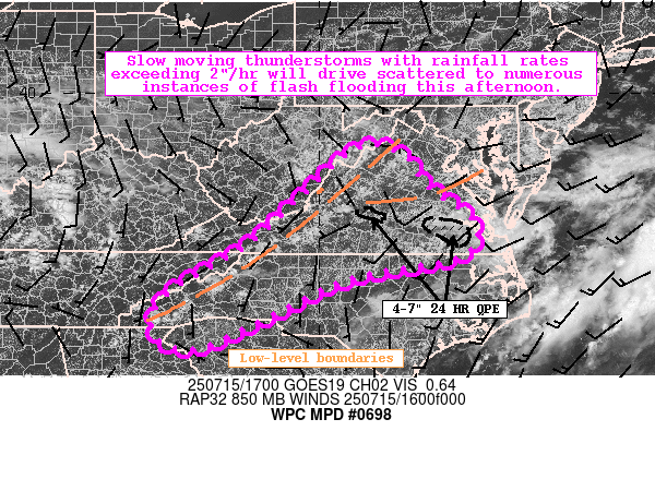
Mesoscale Precipitation Discussion 0698
NWS Weather Prediction Center College Park MD
117 PM EDT Tue Jul 15 2025

Areas affected...Mid-Atlantic into the Southeast

Concerning...Heavy rainfall...Flash flooding likely

Valid 151716Z - 152316Z

Summary...Scattered to numerous instances of flash flooding are
expected this afternoon as coverage of slow moving thunderstorms
exceeding 2"/hr rainfall rates increases.

Discussion...Trends in GOES Day Cloud Phase Distinction and
LightningCast data highlight increased vertical development within
cumulus over portions of the Blue Ridge and Virginia Tidewater.
The uptick in activity are partially tied to a lee-trough, a weak
west-east convergence axis in the 925-850 hPa levels, and modest
DCVA approaching from the west. Recent mesoanalysis data suggests
1500-2000 J/kg of MLCAPE (with minimal CIN) and 1.8-2.2" PWATs
have materialized which will favor efficient warm rain processes
as these cells expand. 10 kts of westerly effective vertical shear
should result in generally disorganized storm modes, but will also
result in slow overall storm motions (5-10 kts) and periodic
mergers to locally enhance rainfall rates in excess of 2"/hr at
times.

Over the next few hours, two areas of focus are expected along the
lee-trough and downstream convergence axis near the Tidewater,
which unfortunately were hit hard yesterday and are sensitive to
any additional rainfall. Accordingly, the HREF and REFS depict
increasing probabilities of 1-3 HR FFG exceedance (over 50%) going
through this afternoon, with localized 2-4" rainfall amounts
expected. While the overall QPF footprint for this activity should
be more scattered compared to yesterday, flash flooding is
considered likely. Considerable to locally significant impacts are
possible atop urban areas and compromised soils.

Asherman

ATTN...WFO...AKQ...GSP...LWX...MRX...RAH...RLX...RNK...

ATTN...RFC...ALR...ORN...RHA...TIR...NWC...

LAT...LON   38827917 38687822 38017772 37267671 36527695
            36037936 35138124 34548269 34838354 35688325
            36758152 37668050
Download in GIS format: Shapefile
| KML
Last Updated: 117 PM EDT Tue Jul 15 2025
|


