| WPC Met Watch |
|
|
Mesoscale Precipitation Discussion: #0561 |
|
(Issued at 637 PM EDT Mon Jun 30 2025
) |
|
| MPD Selection |
|
|
|
|
|

Mesoscale Precipitation Discussion 0561
NWS Weather Prediction Center College Park MD
637 PM EDT Mon Jun 30 2025

Areas affected...Southern Oklahoma...North and Northwest Texas...

Concerning...Heavy rainfall...Flash flooding possible

Valid 302240Z - 010340Z

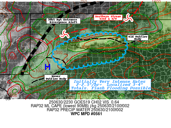
SUMMARY...Initially slow moving, but very efficient thunderstorms
with 2-2.5"/hr rates will slowly propagate south and westward with
storm mergers and localized spots of 3-4" resulting in scattered
incidents of possible flash flooding

DISCUSSION...GOES-E 10.3um EIR shows explosive convective
development along the stalled outflow boundary from this morning's
convective complex from Hughes to Comanche county.  MLCAPEs to
4000 J/kg and total PWats of 2" were trapped along the
northwestern edge of the sub-tropical ridge over much of Texas
into the northwest Gulf, the return flow axis remained nearly
aloft and generally parallel to the surface outflow boundary
though the dip (positive tilt) in the northern stream synoptic
trough has helped with support a 50kt jet with broad right
entrance ascent across much of the TX Panhandle into central OK.

Southerly flow across TX but northern flow out of KS/N OK has
helped to provide ample directional convergence but recent uptick
to 20kts from th south/southwest provided the deep layer
convergence to result in the entire line developing. CIRA LPW
shows the convergence is further increasing flux and TPW values of
2-2.25" that deep layer vertical moisture flux will support very
efficient rates up to 2-2.5"/hr.  That directional shear and
proximity to the jet also support a bit of effective bulk shear
toward 20-25kts for modest organization to keep the downdrafts
fully collapsing into the updrafts and with weak dry air only a
few hundred J/kg will be utilized for cold pool generation.
Combine that with weak steering flow through depth toward the east
at 5kts; propagation will likely be mostly south and west into the
15-20kts of confluent boundary layer flow.  So a hour or so should
support localized totals up to 3-4" before dropping south and
west.

Interaction with cells developing along outflow boundaries from
older complex over the Permian Basin will increase potential for
mergers and storm scale interaction to help cells increase totals
as the complex drops southward into northern TX as well.  FFG
values are reduced further north, so best potential will be early
before moving into higher FFG values along/south of the Red River,
but localized flash flooding is still possible .

Gallina

ATTN...WFO...FWD...LUB...OUN...SJT...TSA...

ATTN...RFC...FWR...ORN...TUA...NWC...

LAT...LON   35319714 35099567 34389521 33349583 32929803
            32589952 32920040 33380108 33890099 34350044
            35069890
Download in GIS format: Shapefile
| KML
Last Updated: 637 PM EDT Mon Jun 30 2025
|


