| WPC Met Watch |
|
|
Mesoscale Precipitation Discussion: #0272 |
|
(Issued at 754 PM EDT Wed May 14 2025
) |
|
| MPD Selection |
|
|
|
|
|

Mesoscale Precipitation Discussion 0272
NWS Weather Prediction Center College Park MD
754 PM EDT Wed May 14 2025

Areas affected...Central SDak...Northern & Central NEB Sand
Hills....

Concerning...Heavy rainfall...Flash flooding possible

Valid 142349Z - 150449Z

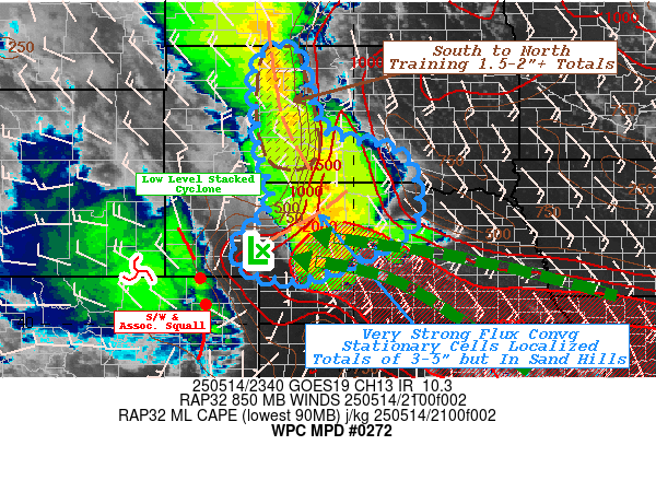
SUMMARY...Expanding convective cluster with very strong moisture
flux convergence, stationary downdrafts and some training elements
suggest spotty 3-4" totals in the Sand Hills and 1.5-2" totals in
Central SDak.  Both may pose a few isolated to widely scattered
incidents of rapid inundation flooding.

DISCUSSION...GOES-East and West WV suite shows a pair of strong
embedded shortwave features (E ID and Northern CO/S WY) carving
out the broaden north-south synoptic trough over the northern
Rockies and northern High Plains.  The pair have helped to provide
a strong deep layer convergence zone across the Dakotas generally
around 101-102W with CIRA LPW denoting pooled mid-level moisture
along and eastward with well above normal 1.25" total PWat values.
 With the main shortwave exiting the WY/CO Rockies, a downstream
boundary layer to 700mb low is stacked across west-central NEB
near LBF, with a strong confluent LLJ streaming from the
southeast.  This LLJ has ample anomalous low level moisture being
advected on 20-30kts with low 60s at the surface and 40-50s into
the boundary layer resulting in 1.3" total PWat, but the flux is
very strong with nearly 90 degrees of directional convergence
along the shear axis across the Sand Hills into the Dakotas.

Moderately unstable air has helped to develop convection
throughout the late afternoon/early evening across Ziebach to
Jackson county in SDak, with recent increase in vigor noted.
Rates of .5"/hr have steadily increased with some spots nearing
1".  The concern is the deep layer steering has allowed for
training elements along it resulting in spots of 1-2" totals
starting to accumulate.  Slow eastward propagation is expected but
will have to wait for a hour or two until height-falls shift the
convergence eastward.  Instability will also be waning through
that time period, so there is a narrow N-S axis for these
increased totals.  Localized spots of 1.5-2"+ are at the tipping
point of 1-3hr FFG values in the area, so a few localized spots
may be exceeded resulting in some flash flooding conditions in the
next 3 hours.

Further south into the Sand Hills, soil conditions can infiltrate
a higher volume of water quickly; however, the very strong
moisture flux convergence along with 1500-2000 J/kg of instability
advected will continue to support strong/broadening updrafts.
This has been particularly impressive in S Cherry county and has
been expanding northward and southward along a stationary front.
Large hail signatures have over-estimated rainfall rates, but the
amount of flux is likely supporting 1.5"+/hr rates as noted by an
observation of 1.2"/hr in Mullen, NEB.  Further saturation of the
deep layer profile will further enhance rates to near 2"/hr in
spots.  Strong height-falls from the ejecting shortwave are
resulting in nearly stationary cell motions as pull west is
counteracted by propagation vectors to the east-northeast.  As a
result, local totals are likely nearing exceeding 2-2.5"; with an
additional 2-2.5" possible in spots.  As such localized 3-4+"
totals may occur locally.  FFG values suggest infiltration through
the sandy soils should take most of these totals, but the shear
magnitude/volume across areas may still result in localized
flooding/ponding especially near roads/urban locations.   As such,
flooding is considered possible across north-central NEB too, but
areas along/surrounding the Sand Hills will be prone for flooding
in south-central SDak before the expanding complex forward
propagates in earnest toward 03-04z.

Gallina

ATTN...WFO...ABR...FSD...LBF...UNR...

ATTN...RFC...MBRFC...NWC...

LAT...LON   45790120 44130068 43739926 43269878 42519867
            41879904 41010090 41100215 41710251 42210192
            42700170 43700197 44340201 45090212 45710191
Download in GIS format: Shapefile
| KML
Last Updated: 754 PM EDT Wed May 14 2025
|


