| WPC Met Watch |
|
|
Mesoscale Precipitation Discussion: #0105 |
|
(Issued at 353 PM EDT Wed Apr 02 2025
) |
|
| MPD Selection |
|
|
|
|
|

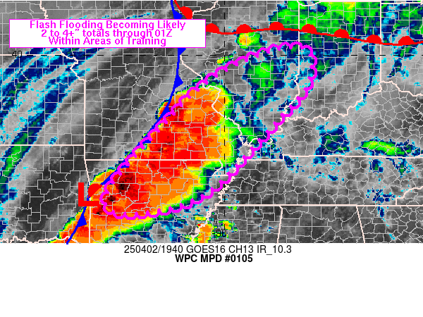
Mesoscale Precipitation Discussion 0105
NWS Weather Prediction Center College Park MD
353 PM EDT Wed Apr 02 2025

Areas affected...northern AR into southeastern MO, southern IL and
western IN

Concerning...Heavy rainfall...Flash flooding likely

Valid 021952Z - 030100Z

Summary...Areas of training are likely to develop across portions
of northern AR into southeastern MO, southern IL and western IN
over the next few hours as an axis of thunderstorms builds north
and slowly translates eastward. Localized 2-4 inch totals are
expected (locally higher).

Discussion...Numerous thunderstorms were ongoing at 1945Z from the
southern OK/AR border into and across the Ozarks, just ahead of an
outflow reinforced cold front. Strong southerly 850 mb winds of
50-60 kt were in place from the lower MS Valley into the lower OH
Valley ahead of a longwave upper trough anchored over the western
U.S., aiding the northward transport of moisture/instability into
the Midwest.

As one shortwave lobe over MN continues to lift north this
evening, weak mid-level height falls over the middle to upper MS
Valley will transition to near neutral height falls down across
the Mid-South as shortwave ridging was evident in water vapor
imagery over KS/OK. This large scale pattern will likely result in
only slow eastward movement to the boundary from southern MO into
western AR. Largely unidirectional flow from the SW in place ahead
of the cold front/outflow will promote short term areas of
training along with repeating cells. Strong low level flow
overrunning convective induced outflow will allow for the
continued regeneration of thunderstorms and rainfall rates of 1-2
in/hr (locally higher). A few locations within areas of training
could see 2-4 inches of rain (locally higher) through 01Z with at
least isolated to widely scattered areas of flash flooding
becoming likely.

Otto

ATTN...WFO...ILX...IND...LSX...LZK...MEG...PAH...SGF...TSA...

ATTN...RFC...ABRFC...LMRFC...MBRFC...NCRFC...OHRFC...NWC...

LAT...LON   40158729 39028726 37758834 35349074 34749336
            35429385 37359227 38999067 40018870
Download in GIS format: Shapefile
| KML
Last Updated: 353 PM EDT Wed Apr 02 2025
|


