| WPC Met Watch |
|
|
Mesoscale Precipitation Discussion: #0098 |
|
(Issued at 1118 PM EDT Sun Mar 30 2025
) |
|
| MPD Selection |
|
|
|
|
|

Mesoscale Precipitation Discussion 0098
NWS Weather Prediction Center College Park MD
1118 PM EDT Sun Mar 30 2025

Areas affected...Eastern Texas...Western Louisiana...

Concerning...Heavy rainfall...Flash flooding possible

Valid 310320Z - 310900Z

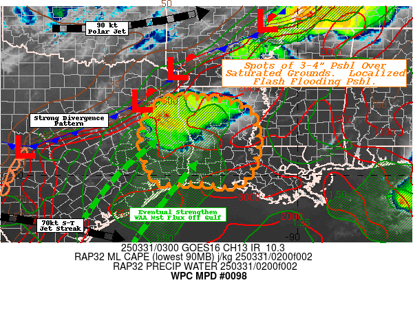
SUMMARY...A favorable back-building environment/slow cell
propagation will give way to broader warm advection off the
western Gulf resulting in expanding convective cluster into the
middle overnight period.  Rates of 2-2.5"/hr and spots of 3-4"
totals across recently saturated grounds pose possible localized
flash flooding to continue through early morning.

DISCUSSION...03z Surface analysis depicts a well defined front
stretching from the Delta region of E AR across toward Texarkana
before sagging south across central TX.  A pool of enhanced low
level moisture exists through the Sabine River Valley nosing
toward the frontal zone with Tds in the lower 70s and some return
moisture off the western Gulf supporting 1.5-1.75" total PWats.
Aloft, GOES-E WV suite denotes a 3H 90kt speed max tracking across
OK before cyclonically curling northeast across AR/S MO; while the
sub-tropical jet axis dives south across the Rio Grande and
southern TX, providing a strong divergence pattern aloft.  This
combination of factors has resulted in a few thunderstorms near a
weak surface to boundary layer low near TYR.  While winds are
weak, boundary layer inflow is out of the W and SW per upstream
VWP noting solid inflow and ability of convection to backbuild
over the last hour or so.  This is noted well in the cycling
overshooting tops in 10.3um EIR as well, limiting forward
propagation of the heavy rainfall cores.   While dry/cooler air
aloft is supporting hail generation, there is ample moisture flux
to support 2"/hr rates; and localized spots of 2-4" are already
starting to be estimated.   While not particularly confident due
to edge of the convective domain, recent WoFS solutions suggest
back-building cells may even be capable of 4-6" totals per 50th to
90th percentile totals.

The favorable divergence should be slackening over the next 3-5hrs
to reduce this potential back-building.  However, this will come
with the diurnal increase in southwesterly flow off the western
Gulf with increased warm-advection after 06-07z.  Combined with
eastward approach of stronger shortwave/general height-falls,
convective over-turning is expected further south and east.
Moisture flux convergence into the cells will be prolific with
Pwats nearing 2.0" and confluent 25-30kt 850mb flow will support
2-2.5"/hr rates.  Slow forward propagation is expected allowing
for spot totals of 3-4".  Overall, the area has been quite
saturated with 0-40cm percentiles over 85% per NASA SPoRT and
saturation ratios of 65-80% across the area of concern/convective
development.  As such, spots of flash flooding are likewise
considered possible through early morning across W and SW LA.

Gallina

ATTN...WFO...HGX...JAN...LCH...LIX...SHV...

ATTN...RFC...LMRFC...WGRFC...NWC...

LAT...LON   32589312 32329195 31969154 31139137 30189160
            29679216 29799335 29749454 30029489 31019526
            31989506 32529448
Download in GIS format: Shapefile
| KML
Last Updated: 1118 PM EDT Sun Mar 30 2025
|


