| WPC Met Watch |
|
|
Mesoscale Precipitation Discussion: #0092 |
|
(Issued at 511 AM EDT Fri Mar 28 2025
) |
|
| MPD Selection |
|
|
|
|
|

Mesoscale Precipitation Discussion 0092
NWS Weather Prediction Center College Park MD
511 AM EDT Fri Mar 28 2025

Areas affected...Lower Rio Grande Valley of Texas...

Concerning...Heavy rainfall...Flash flooding likely

Valid 280915Z - 281400Z

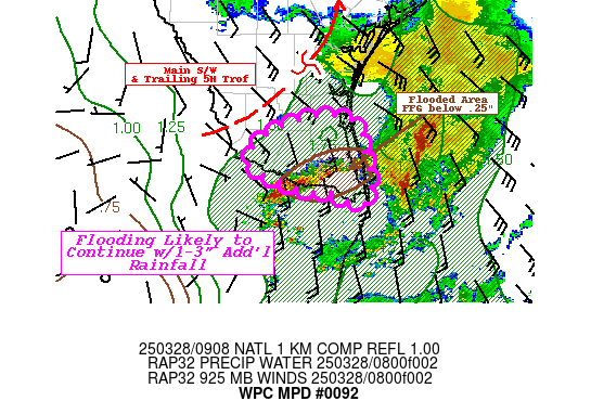
SUMMARY...A few more hours of showers/thunderstorms repeating
across already flooded locations.  Additional 1-3" totals
possible, continuing flooding conditions through day break.

DISCUSSION...GOES-E WV suite depicts core of MCV/vorticity center
lifting north-northeast across South Texas with a trailing
shortwave rounding out the bottom of the filling mid to upper
level trough that has been persistent across central TX over the
past few days.  In the process the progressive squall line has
moved into the northwest Gulf, but with some weak DPVA upstream,
low-level winds have returned to south/southeast from the surface
to boundary layer off the western Gulf.  GOES-E 3.9um SWIR loop
showed low level stratus at the leading edge of the return
moisture, modest instability field lifted north but along
weakening winds into the 15-25kts range from 925mb VWP in the
area. Veered flow across 850-700mb with weak WAA allowed for some
convection to refocus and build across Hildalgo to W Cameron
county. Weaker flux of still ample deep layer moisture of 1.75-1.9
Total PWat and 1000 J/kg, support rates up to 1.5"/hr but given
the veered steering flow aloft will once again allow for cells to
train ENE across significantly flooded areas with an additional
1-3" totals expected, likely to maintain ongoing flooding
conditions.

Hi-Res CAMs continue to struggle with the placement and timing of
the evolution of the convection.  However, early HRRR runs showed
a similar evolution through the Lower Rio Grande Valley but had
been about 2 to 2.5 hours too slow with the timing of the squall
line and the ongoing redevelopment.  Still, the evolution seems to
be the best handle on the situation, as such there most recent run
has backed off a tad, suggesting the convergence and ascent
pattern may be weakening with greater surface to boundary layer
winds turning eastward across the Northwest Gulf over the next 3-5
hours finally giving the area of concern a break from these
repeated rounds.  Given the run to run variability and poor
performance from other CAMs, not fully confident that additional
convection may maintain at the trailing edge of the low level
confluence of the larger cyclonic circulation as it lifts
northeast across Northeast Texas later this morning as hinted by
the recent RAP runs.

Gallina

ATTN...WFO...BRO...

ATTN...RFC...WGRFC...NWC...

LAT...LON   26969773 26889732 26519720 25989709 25799730
            25969771 25979800 26129846 26339890 26659872
            26909818
Download in GIS format: Shapefile
| KML
Last Updated: 511 AM EDT Fri Mar 28 2025
|


